Estimating Chlorophyll-A Concentration using Remote Sensing Techniques- Juniper Publishers
Juniper Publishers- Open Access Journal of Annals of Reviews & Research
Estimating Chlorophyll-A Concentration using Remote Sensing Techniques- Juniper PublishersAuthored by Şeyma Merve Kaymaz
Abstract
Chlorophyll-a is used as an indicator of the mass of phytoplankton, and as a reference for estimating organic influence in the aquatic area. This study discusses the spatio-temporal distribution of chlorophyll-a in the Marmaris Bay. The aim of the study is to be a source of information on how to use remote sensing technology in the marine field. Chl-a level is identified using Sentinel 2A satellite images in the May 2017 and May 2018. The chl-a levels were higher in the coastal areas than the open sea. The results obtained from the satellite images should be compared with the laboratory results and the accuracy should be confirmed.
Keywords: Chlorophyll-a; Remote sensing; Sentinel 2A; Algorithm; Estimation
Introduction
Chlorophyll-a is found in algae and other phytoplankton in the surface water. Chlorophyll-a is one of the ecological indicators used to evaluate the ecological status of marine environment. This pigment cell is used to energy from sunlight to produce oxygen for life-sustaining. To monitor chlorophyll levels is a way of tracking algal growth. The high chlorophyll levels are high in nutrients in the surface waters. The nutrients cause the growth of algae. When populations of algae is bloom, then crash and die in reply to change ecological situations. This situation cause to decrease dissolved oxygen levels. High levels of nutrients are pollution indicators from anthropogenic sources. Thus, measuring of chlorophyll can be evaluated as an indicator of levels of nutrients [1].
Using of remote sensing techniques in the estimation and creation of map of chlorophyll-a level evaluated an significant tool monitoring water quality and assessment in marine and fresh waters as it is both time and economically efficient [2,3].
Remote sensing technology is monitoring the water behaviour through satellites. Depending on the satellite various creates images involve of several band. Chl-a estimation is one of the best scientific applications of remote sensing [3,4]. Several algorithms were developed and applied to chla map in marine areas, estuaries and fresh water mass [5-8]. In the study, the show of usually used algorithms for chla prediction based on Sentinel 2A satellite images. These bands were considered through analysis of values of water surface reflectance [9]. The images results were provided spatio-temporal distribution of chla estimation in the Marmaris Bay, to better know the marine’s ecosystem health and status of water quality.
Materials and Methods

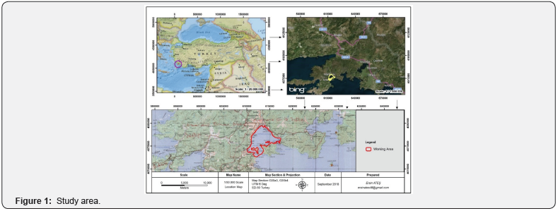
Marmaris Bay is selected as study area (Figure 1). Marmaris is a coastal city located in the district of Mugla (Southern-West of Turkey).
In this study Sentinel 2A satellite data are used, two satellite images (May 2016 and May 2018) were taken from the Marmaris Bay. Sentinel 2A images are used as a representation of the distribution of chlorophyll-a.
The processing of Sentinel 2A imagery are done using ArcGIS 10.5 software for radiometric correction, calibration, cropping and implementation of algorithm. Radiometric correction is done reducing or correct errors in the Digital Numbers (DN) of images [6,10]. The process of cropping is done to minimize the image of the study area. To estimating chlorophyll-a value is using algorithm (Equation 1) to convert reflectance values of images [4,8,11,12].
Equation;

Results
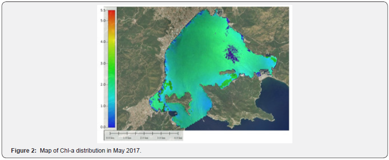
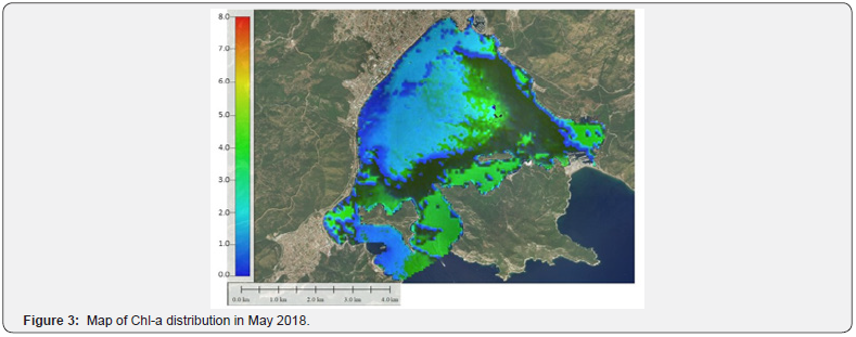
Values of chlorophyll-a concentration in the study area, according to Sentinel 2A imagery processing, that the range values of May 2017 were estimated between 0.01-5.5 μg/L (Figure 2), the values of May 2018 were estimated between 0.028-8.00 μg/L (Figure 3).


Discussion
The study discusses about the chl-a result of the applied algorithm. The chlorophyll-a values were spatially to have significant differences in the study area. In May 2018, the range of chl-a amounts were higher than May 2018. The increasing of chl-a value is evaluated an indicator of organic pollution in the marine system. Chl-a level is high in the area near with coastal zone. This reason of high production of phytoplankton might be the consequence of entry additional nutrient supply by runoff of streams flow.
Conclusion
The satellite images acquired are used in the field of studies currently. The proposed study can be applied to estimate the chl-a level in the marine areas. The algorithm which is used in the paper, was given good result in the area. The results obtained from the satellite images should be compared with the laboratory results and the accuracy should be confirmed.
To know more about Juniper Publishers please click on: https://juniperpublishers.com/aboutus.php
For more articles in Open
Access Journal of Reviews & Research please click on:
https://juniperpublishers.com/arr/index.php


Comments
Post a Comment